LEHMANN AVIATION LTD.
Lehmann Aviation LM450
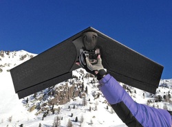
The LM450 is
designed for long range missions with still images (12Mp) or up to 2.4k HD
videos capabilities. LM450 is our first UAV coming with an advanced navigation
system, enabling fully autonomous flight.
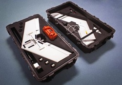
To ensure system interoperability, LM450 uses the same advanced technology found in other LA systems, such as LP960 and LV580, and is controllable through a common Ground Control System (GCS).
To ensure system interoperability, LM450 uses the same advanced technology found in other LA systems, such as LP960 and LV580, and is controllable through a common Ground Control System (GCS).
Lehmann Aviation LP960
The LP960 is
a rugged unmanned aerial platform designed for creating geo-referenced
orthomosaics and digital elevation models (DEM), as well as high resolution
vertical photos.
To ensure system interoperability, LP960 uses the same advanced technology found in other LA systems, such as LM450 and LV580, and is controllable through a common Ground Control System (GCS).
To ensure system interoperability, LP960 uses the same advanced technology found in other LA systems, such as LM450 and LV580, and is controllable through a common Ground Control System (GCS).
Lehmann Aviation LV580

The LV580 is
a rugged unmanned aerial platform designed for day or night aerial survey, live
event or Tv's videos.
To ensure system interoperability, LV580 uses the same advanced technology found in other LA systems, such as LM450 and LP960, and is controllable through a common Ground Control System (GCS).
To ensure system interoperability, LV580 uses the same advanced technology found in other LA systems, such as LM450 and LP960, and is controllable through a common Ground Control System (GCS).
